Mobirise

Administrator client application mode


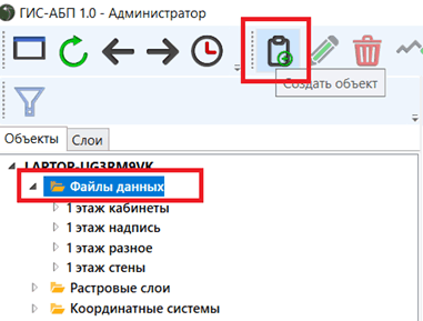
In the “Administrator” client application mode all the same functionality is available as in the “Operator” and “Developer” operating modes
 
Additionally, in the "Developer" mode, the GIS-ABP application allows you to create new data structures (files) and edit their properties, as well as execute built-in administrator commands.
 
Automated data loading is described in the Embedded Commands section.
 
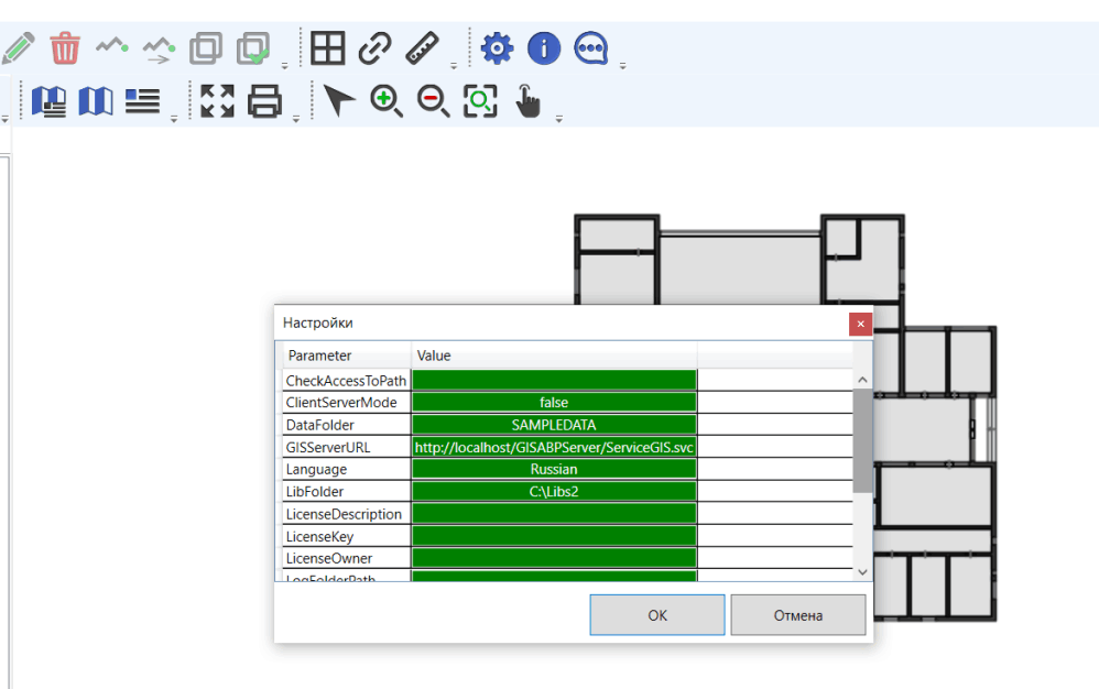
Before you begin, copy the SAMPLEPLAN directory, which is located in the application directory (C:\Program Files (x86)\ABP\GIS-ABP\ SAMPLEPLAN), to the root directory of the drive, for example, drive C :. The directory C:\SAMPLEPLAN must have the current user full access permissions. This is necessary for editing data.
 
Launch the GIS-ABP Client Application.

Mobirise

Click the "Settings" button.

Mobirise

In the settings window that opens, set C: \ SAMPLEPLAN as the value of the DataFolder and RasterDataFolder parameters, the value of the ClientServerMode parameter is false, click OK.

Mobirise

Select the "Data Files" folder in the tree, click the "Create Object" button.

Mobirise

Input the name of the new data file (layer), click OK.

Mobirise

Select the file type DataFile, click OK.

Mobirise

Types of data files:
· DataFile - the file data is visible to all users, available for editing in the operating modes of the Developer and Administrator applications, the properties of the data file can be configured only in the operating mode of the Administrator application;
· Sketch - the file data is visible to all users, available for editing in the Operator, Developer and Administrator modes, the properties of the data file can be configured only in the Administrator application mode;
· Analytics – the data file and its data are visible only to the user who created it, the file data is editable in any application mode, the properties of the data file can be configured in any application mode, the user who created the data file of the Analytics type can delete it.
A new data file has appeared in the object tree.

Mobirise

  The attribute menu displays the properties of the created file. The size of the square is the cell size of the spatial index, calculated automatically by the system.

Mobirise

Click "Save." 

Mobirise

  Select the “Properties” folder of the created data file, click “Create Object”.

Mobirise

Input the name of the new property - “Name”, click OK.

Mobirise

In the attribute menu, specify the parameters of the created property.

Mobirise

Type – stringType;
Username - True (displaying the value of the created property in the name of the object);
Label content – True (displaying the value of the created property in the label of the object).
 
Click Save. 

Mobirise

The "Title" property is displayed in the properties of the new data file.

Mobirise

Select the "Properties" folder in the tree, click the "Create Object" button.

Mobirise

Indicate the name of the new property - "Geometry", click "OK".

Mobirise

In the attribute menu, specify the value of the Type parameter - "geometryType", leave the values of the remaining parameters false.

Mobirise

Click Save.

Mobirise

Select the "Geometry" property in the tree, click "Create Object".

Mobirise

Select the geometry type “Area”, click OK (possible types are Point, Line, Area).

Mobirise

Select the type of coordinate system "Scheme", click OK

Mobirise

Select “Meters” units, click OK.

Mobirise

Select the “Mathematic” axis type, click OK (Mathematic - the X axis is horizontal, the Y axis is vertical, and the Geodetic is vice versa).

Mobirise

Set the geometry parameters, click "Save."

Mobirise

ZIndex - the position of the geometries of the current layer relative to the geometries of other layers;
Minimum scale, Maximum scale - scale filtering parameters that define the range of scale values at which this layer should be displayed.


A default style was automatically created in the Geometry property style collection. If necessary, you can add additional styles and filters - this will allow you to display objects of a given layer with various styles selected by the filter, depending on the values of the properties of the objects

Mobirise

You can start drawing. Turn on the grid. Select the Objects folder of the created data layer (file), click Create Object.

Mobirise

Place the geometry of the object, click the right mouse button.

Mobirise

Fill in the value of the “Title” property, click “Save”.

Mobirise

Turn off the grid. The created object is displayed on the map.

Mobirise

Edit the color of the area of the new layer.

Mobirise

The color of the area has changed.

Mobirise

Also, in the “Administrator” application operating mode, you can configure the Linked data files to build a connectivity model.

ADDRESS

192148, Russian Federation, St. Petersburg, Autogennaya street,
house 10, office 422/3

CONTACT

Tel +7(921) 862-98-09
Email: info@abpsoft.spb.ru