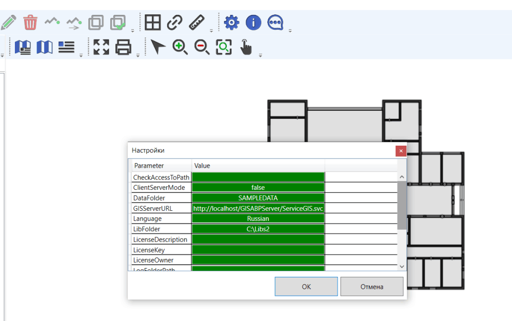
It is necessary to fill in the values of the following parameters:
· CheckAccessToPath - a list of folders separated by semicolons, access to which the application will automatically check (for example, C:\ Data; C:\ Libs) and, if there is no access, will prompt you to enter a username and password to connect to the folder. Such a situation is possible, for example, if the data folder is located on another computer, access to which is limited (for example, a connection is made to the domain computer from your home computer). If you do not need to check access to folders, leave the value of the CheckAccessToPath parameter empty. The folders to which you can check the connection if necessary are the parameter values:
DataFolder;
LibFolder;
LogFolderPath;
RasterDataFolder.
· ClientServerMode – when connecting directly to data, the value must be false;
· DataFolder – the folder where the data files are located. By default, after installing the application, the value of the SAMPLEDATA parameter is a folder with test data located in the application directory. Because in this directory, access to files is usually possible only in read mode, data editing mode will be disabled. Create an empty folder, for example C: \ Data, give it full access and specify the path to this folder in the DataFolder parameter value field. Test data files can be copied from the SAMPLEDATA folder (usually its path is C: \ Program Files (x86) \ ABP \ GIS-ABP \ SAMPLEDATA) or SAMPLEPLAN (path C: \ Program Files (x86) \ ABP \ GIS-ABP \ SAMPLEPLAN) to the C: \ Data folder you created. The Functionality section will provide examples of working with the data of the SAMPLEPLAN folder, therefore it is better to copy the data of this folder;
· GISServerURL – the value of this parameter is not used in direct data connection mode;
· Language – possible values of the parameter Russian and English;
·LibFolder – the folder in which the libraries with additional functionality are located (for more details on creating additional functionality, see the "Development" section);
· LicenseDescription, LicenseKey, LicenseOwner - license key parameters. The application will work with empty parameters of the license key for 30 days from the moment of the first installation - this is a test period;
· LogFoldePath – folder for recording diagnostic files (log files). If you do not need to create diagnostic records, leave the value of this parameter empty;
· ObjectsFile – library file, which contains the main functionality of the geographic information system. As a rule, the parameter value is specified by the relative path of ObjectLibrary.dll, or by the absolute C: \ Program Files (x86) \ ABP \ GIS-ABP \ ObjectLibrary.dll;
· RasterDataFolder – the folder in which the raster layer description files will be placed;
· RootTypeName – the name of the root data type used in the ObjectLibrary.dll library, the parameter value should be - Machine;
· StepGrid – grid lines step;
· ToleranceSnapGrid – sensitivity of automatic snap to grid lines.
After editing the parameter values, click OK - the configuration is completed.